State Legislatures

The Complete Lower Houses of the United States

Coming soon - all these products are currently in development. Already know you want one? Punch your favorite state into this contact form - every response makes the maps come out faster!

Complete map of all 50 state legislatures
← A truly ridiculous 120 inches wide (ships in two parts) →
← 36 inches tall →
Click map to open preview in new tab. (5MB)

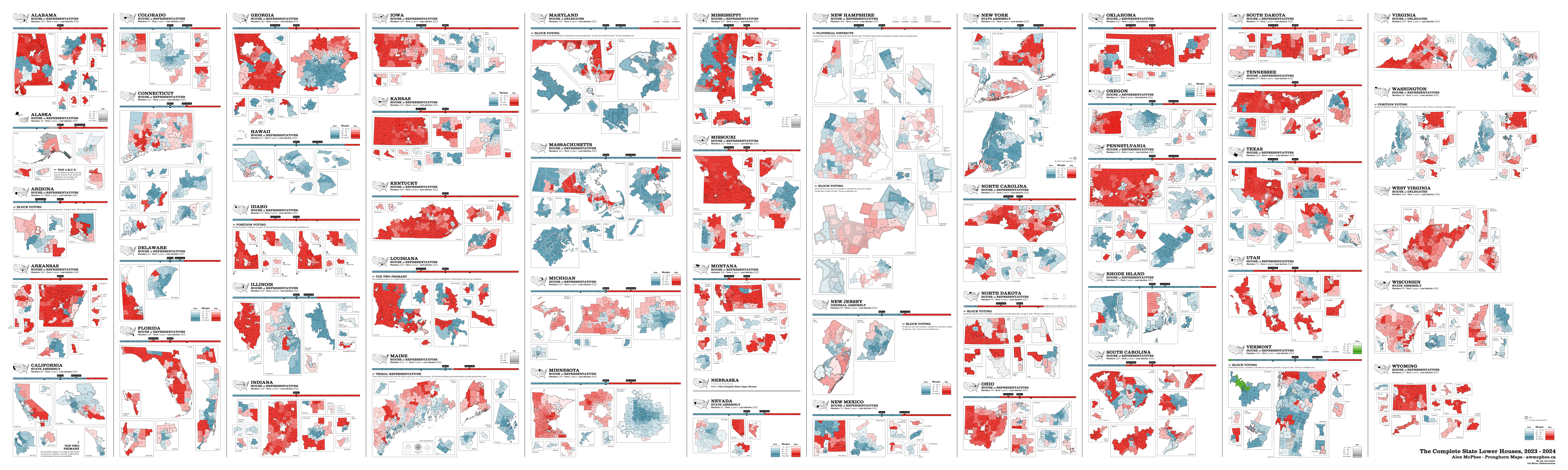
Do you work with state representatives? This mighty map is a work in progress with one goal: show every state legislature at a glance on one page. I hold multiple industry awards in cartographic design, and my election maps elegantly visualize odd errata that other maps struggle with - all in colorblind-accessible format.

The Complete Lower Houses will easily fill an entire wall upon completion, and will retail at $499. New editions will be available with annual update frequency.

State Legislature Maps

Map of the Texas House of Representatives.

The perfect gift for the political buff or minor elected official in your life.

Historical maps

I have been interested in mapping state legislatures for a while. Here are some past projects, now out-of-date.

A political map of Alabama.

Alabama

A political map of Alaska.

Alaska

A political map of Arizona.

Arizona

A political map of Arkansas.

Arkansas

A political map of California.

California

A political map of Colorado.

Colorado

A political map of Connecticut.

Connecticut

A political map of Delaware.

Delaware

A political map of Florida.

Florida

A political map of Georgia.

Georgia

A political map of Hawaii.

Hawaii

A political map of Idaho.

Idaho

A political map of Illinois.

Illinois

A political map of Indiana.

Indiana

A political map of Iowa.

Iowa

A political map of Kansas.

Kansas

A political map of Kentucky.

Kentucky

A political map of Louisiana.

Louisiana

A political map of Maine.

Maine

A political map of Maryland.

Maryland

A political map of Massachusetts.

Massachusetts

A political map of Michigan.

Michigan

A political map of Minnesota.

Minnesota

A political map of Mississippi.

Mississippi

A political map of Missouri.

Missouri

A political map of Montana.

Montana

A political map of Nebraska.

Nebraska

A political map of Nevada.

Nevada

A political map of New Hampshire.

New Hampshire

A political map of New Jersey.

New Jersey

A political map of New Mexico.

New Mexico

A political map of New York.

New York

A political map of North Carolina.

North Carolina

A political map of North Dakota.

North Dakota

A political map of Ohio.

Ohio

A political map of Oklahoma.

Oklahoma

A political map of Oregon.

Oregon

A political map of Pennsylvania.

Pennsylvania

A political map of Rhode Island.

Rhode Island

A political map of South Carolina.

South Carolina

A political map of South Dakota.

South Dakota

A political map of Tennessee.

Tennessee

A political map of Texas.

Texas

A political map of Utah.

Utah

A political map of Vermont.

Vermont

A political map of Virginia.

Virginia

A political map of Washington.

Washington

A political map of West Virginia.

West Virginia

A political map of Wisconsin.

Wisconsin

A political map of Wyoming.

Wyoming

A political map of Puerto Rico.

Puerto Rico

A postage stamp
Nowadays you'll need at least two pronghorn stamps to deliver anything.
alex@awmcphee.ca
Box 201, Val Marie SK, S0N 2T0